

The Cruz de Calar is positioned on the ridge to the north of the village of Guejar Sierra. It is a good day-hike for someone on a day-trip from Granada as you reach the Cruz (Cross) at the top within a couple of hours making it easily accessible for those wishing to have a hike but also see the town or take in a swim at the river. It also has stunning views of the high Sierra Nevada peaks in the distance, and has a good selection of local flowers and wildlife if you are lucky.
Difficulty: Medium
Time: 1.5 hours to the Cruz de Calar. 1h back to Guejar Sierra.
From the Plaza del Ayuntamiento (Main Square) you can either walk through the town to the Barrio Alto (upper neighbourhood) and to Fuente de los 16 canos, or follow the directions below to get out of the town on a small path along the water system
From the Plaza del Ayuntamiento, continue straight up the hill on Calle Carrera towards the Spar Supermarket at the top of the street. Here take a right turn onto Calle Aguas. After 10m turn left onto Camino Prados. At the top of the street, the road name changes to become the Sotellejo and at this point take a narrow, steep, path to the left between the Casa Rural Conjunto Los Prados and a stone retaining wall.
When the path rejoins a tarmac road after 40m turn to the right. After 30m this will turn to dirt and become a series of switchbacks leading up the hillside inbetween vegetable gardens and orchards.
20m after the 4th switchback (look out for a large white building which is the town water purification plant on the 3rd bend) there is a 2m wide path on the LHS flanked by brambles. Take this path and after another 20m it will join the now covered Acequia de la Solana (water irrigation canal). Note here the rocky walls above you further up on the right and look out for climbers.
Continue to the left underneath the rocks and later between fenced off olive and almond groves. As you round the corner the Barrio Alto of Guejar will be visible and the Canales Reservoir will come into view.
When you reach a small water deposit there is an intersection of paths. The left hand downhill path goes to the Fuente de los 16 Canos (50m) where you can get water if you need more. (Note there is no water source on the rest of the hiking route). Take the uphill righthand path towards the Cruz de Calar.
The track wil start out quite wide and is over rutted, water-eroded, limey soil.
After less than 100m you reach a post on the LHS with a small painted arrow signalled to the left.

The path is steep and rocky and you will smell the wild herbs underfoot and in a couple of bends again there is a post signalling to the left.
After some more switchback bends there is a third post signalling the path continuing to the right skirting a large open field full of almond trees and with the stone ruin of Cortijo de las Lastras. If you are here in Spring, this is a great spot to see the contrast of the lush green valley covered in almond blossoms against the high snowy peaks of the Sierra Nevada in the background. At any other time of year the views are still great and it is the first point on the hike that the high peaks of the Sierra Nevada can be seen in the distance. From here you can also see the path that you will follow to the Cruz de Calar.
 Once past this open field the path starts to climb, heading up the middle of the valley always keeping the rock cliffs and pylon posts to the left (where you can when higher up look out for the chuffs normally flying around the rocky walls). Look out for the Cruz de Calar visible on the rocky skyline to the right.
You can also note here the different goat paths if you want to vary your downhill route.
After around 40 minutes there are some large rocks across the path that continues straight on towards the col on the horizon. Instead here take the obvious path to the RHS towards the Cruz de Calar. The path levels out but only for a short time and then again climbs.
As you round the corner on the way to the Cruz, look out on the LHS for a cave entrance to an old mine now covered in brambles.
After the cave entrance you will pass a stretch of 100m or so of bare branches on all the bushes after they were burned in a forest fire in 2009? From here ther is little climbing left until you reach the Cross.

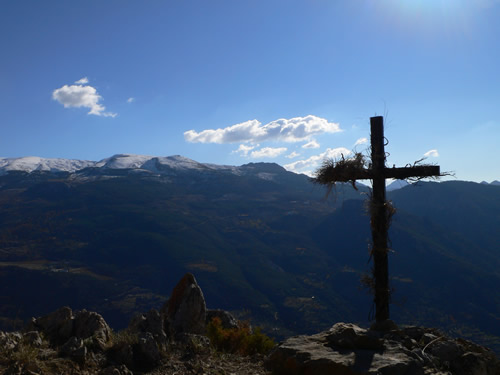
From here you have wide views of the whole valley. The peaks of Alcazaba and Mulhacen are both visible, and the famous “Vereda de la Estrella” stretches out from Guejar to meet the high mountains. You can see the old tunnels leading out of the valley away from Guejar Sierra towards the high mountains, where the old tramway once brought people from Granda city centre. To the right you can see the city of Granada and its outlying suburbs far in the distance.
Things to note:
Bring water from any of the springs in town or else fill up at the “Fuente de los 16 canos” at the start of the hiking trail from the Barrio Alto.
On May 3rd, which is a holy day in Spain, locals climb to the Cruz de Calar to decorate it with rosemary and wildflowers.
In April and May if you are lucky you can see Golden Eagles playfully flying around and soaring the cliff faces underneath the Cruz.
[sgpx gpx=”/wp-content/uploads/gpx/guejar-sierra-05-03-14-calar-de-guejar-sierra.gpx”]


